- Aspex Drones
- RegenAg
- Agricultural
- Agricultural Drone Services for Crop Monitoring & Precision Farming
- Agricultural Drone Services for Crop Monitoring & Precision Farming – Chinchilla
- Agricultural Drone Services for Crop Monitoring & Precision Farming – Goondiwindi
- Agricultural Drone Services for Crop Monitoring & Precision Farming -Moree
- Agricultural Drone Services for Crop Monitoring & Precision Farming – St George
- Agricultural Drone Services for Crop Monitoring & Precision Farming – Temora
- Agricultural Drone Services for Crop Monitoring & Precision Farming – Wagga Wagga
- Agricultural Drone Services for Crop Monitoring & Precision Farming – Walgett
- Precision Viticulture with Drone-Based Multispectral Imaging – Hunter Valley
- Precision Viticulture with Drone-Based Multispectral Imaging – Riverina
- Precision Viticulture with Drone-Based Multispectral Imaging – Orange
- Precision Viticulture with Drone-Based Multispectral Imaging – Mudgee
- Agricultural Drone Services for Crop Monitoring & Precision Farming
- Aerial Photography
- Asset Inspections
- Construction
- Precision Mapping
- Solar Farm and Wind Farm
- Service Areas
Specialist Drone Mapping, Aerial Survey & Inspection Services Across Australia
Advanced Drone Mapping
Precision You Can Trust, Speed You Can Count On
Are you facing challenges with slow, costly, or hazardous traditional mapping methods? Skyspec Drone Services offers a transformative solution by providing fast, accurate, and safe drone mapping services. Our advanced drones can access hard-to-reach areas and deliver high-resolution data, reducing the time and risk associated with manual surveys.
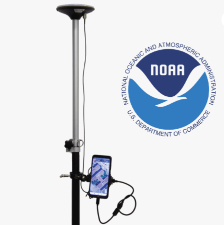
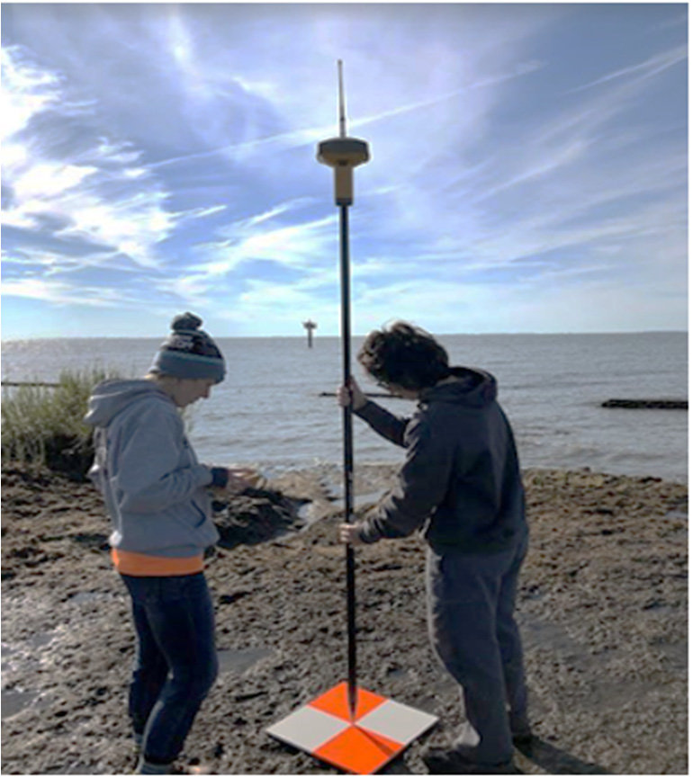
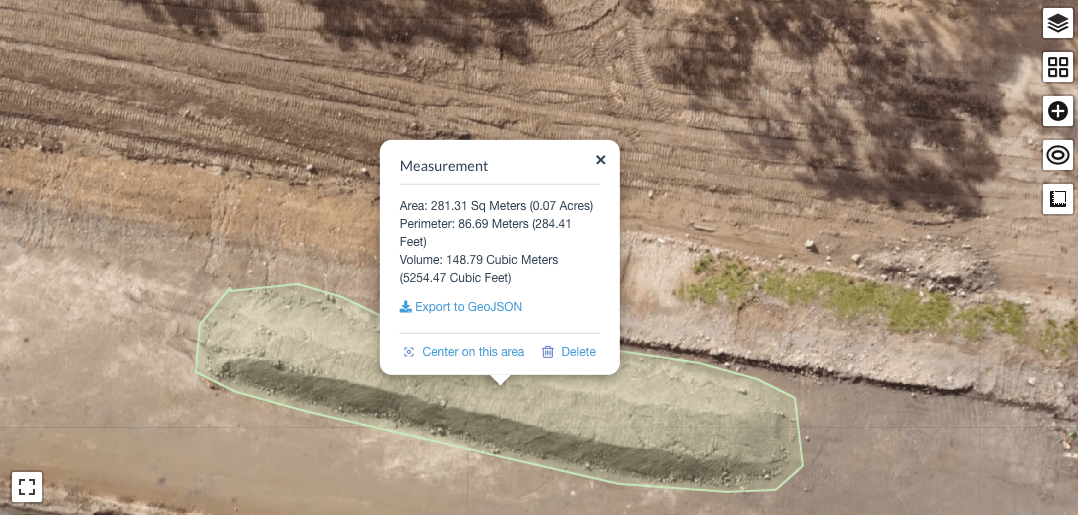
At Skyspec, we understand that precision matters. Our RTK-enabled drones, supported by NTRIP networks, provide real-time corrections that eliminate the need for ground control points, streamlining your workflow and reducing field time. This technology is particularly beneficial for applications requiring high spatial accuracy, such as volumetric surveys, topographic mapping, and asset inspections. With our expertise and cutting-edge equipment, you can trust Skyspec to deliver data that meets the highest standards of accuracy and reliability
With Skyspec, you gain a partner committed to enhancing your project’s efficiency and accuracy. Our drone mapping services provide detailed insights, enabling better decision-making and streamlined operations. Experience the benefits of modern mapping technology with Skyspec Drone Services.
Agricultural Drone Mapping. Weed, Soil and Crop Mapping by Drone.
Precision Farming Starts Here—Cut Costs, Boost Yields, and Farm Sustainably
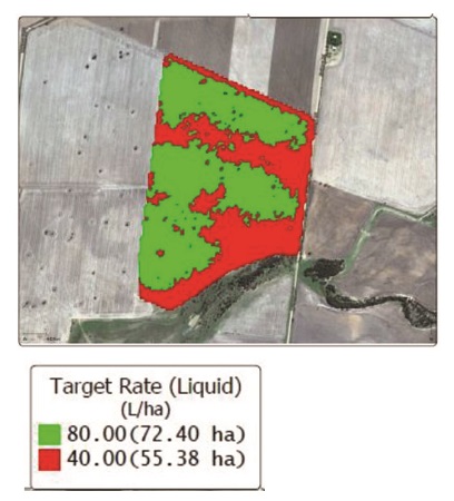
Struggling with patchy crop yields, escalating herbicide costs, or undetected pest outbreaks? Skyspec Drone Services offers cutting-edge agricultural mapping solutions to address these challenges head-on. Our drone technology provides detailed weed distribution maps, enabling targeted herbicide applications that can significantly reduce chemical usage and costs . Additionally, our multispectral imaging detects early signs of crop stress, pests, and diseases, allowing for timely interventions that enhance crop health and productivity.
Skyspec provides you high efficiency weed mapping through the use of a fixed wing drone fitted with a high-tech multispectral sensor.
In our part of the world, broadacre green on brown (fallow) weed mapping represents a large part of the requirements of local growers. Skyspec is well equipped to assist with high efficiency fallow weed detection.
Our drone of choice is the Sensefly (now Ag Eagle) fixed wing eBee Plus fitted with a Sequoia multispectral sensor. The eBee plus is capable of up to 200 Ha per hour, making it ideal for broadacre applications. This keeps your weed mapping costs under control.
Unlock unparalleled precision with Skyspec Drone Services—your trusted partner for high-accuracy drone mapping across Australia. We specialize in centimeter-level accuracy using Real-Time Kinematic (RTK) technology combined with NTRIP corrections, ensuring your geospatial data is both reliable and actionable. Whether you’re managing a mining operation, overseeing agricultural lands, or conducting infrastructure inspections, our advanced drone solutions deliver the exactitude you need to make informed decisions.
With Skyspec, you gain access to precise, real-time data that informs better decision-making and optimizes resource allocation. Our services help you monitor crop growth, assess soil conditions, and manage irrigation more effectively, leading to improved yields and sustainable farming practices . Partner with Skyspec Drone Services to transform your agricultural operations through innovative mapping solutions tailored to your farm’s unique needs.
Construction Monitoring and Project Reporting by Drone
No More Guesswork—Real-Time Progress and Powerful Insights from Above
Construction projects often face challenges such as delays, budget overruns, and communication breakdowns among stakeholders. Traditional monitoring methods can be time-consuming and may not provide real-time insights into project progress. Skyspec Drone Services offers advanced drone construction monitoring solutions that provide accurate, up-to-date aerial imagery and data. This technology enables project managers to track progress efficiently, identify potential issues early, and make informed decisions to keep projects on schedule and within budget.
Effective communication among stakeholders is crucial for the success of construction projects. Skyspec’s Drone Services facilitate improved collaboration by providing high-resolution visuals and comprehensive reports that can be easily shared with all parties involved. These detailed insights help ensure that everyone, from on-site teams to remote stakeholders, has a clear understanding of the project’s status, fostering transparency and alignment.
From Facades to Towers—Drone Inspections That Cut Risk, Cost, and Downtime
Maintaining critical infrastructure like cell towers, transmission lines, and communication masts presents significant challenges, including safety risks, high costs, and the need for detailed documentation. Traditional inspection methods often require technicians to climb structures or use helicopters, exposing them to hazards and increasing operational expenses. Skyspec Drone Services offers a safer, more efficient alternative by utilizing drones equipped with high-resolution cameras and sensors. These drones can capture comprehensive data from multiple angles, allowing for thorough inspections without the need for manual climbing or expensive aerial equipment. This approach not only enhances safety but also reduces inspection time and costs, providing clients with accurate, actionable insights into their assets’ conditions.
For building owners and facility managers, inspecting facades and roofs, especially on older or high-rise structures, can be daunting. Issues like weathering, structural damage, and water intrusion require prompt attention to prevent further deterioration. Skyspec’s drone services enable detailed facade and roof inspections without the need for scaffolding or lifts. Our drones can access hard-to-reach areas, capturing high-resolution imagery and thermal data to identify problems such as cracks, moisture ingress, or insulation failures. This method not only ensures comprehensive coverage but also minimizes disruption to building occupants and operations.
Roof inspections, particularly for detecting thermal anomalies, are crucial for maintaining building integrity and energy efficiency. Traditional inspection methods can be time-consuming and may not effectively identify hidden issues. Skyspec employs drones equipped with both RGB and thermal imaging cameras to conduct thorough roof assessments. These drones can quickly identify areas of heat loss, moisture accumulation, or structural weaknesses, providing clients with precise data to inform maintenance decisions. By leveraging this technology, property managers can proactively address issues, extend the lifespan of roofing systems, and ensure optimal energy performance.
Solar Farm Thermography
At Skyspec Drone Services, we specialize in cutting-edge solar thermography to help solar farm owners and operators maximize efficiency and detect potential issues before they escalate. Using advanced drone technology and our partnership with Sitemark, we provide high-resolution thermal imaging and data-driven insights, ensuring optimal performance and minimal downtime for your solar assets. Our precise aerial inspections identify defective panels, hotspots, and wiring issues, enabling proactive maintenance and improved energy yield. Trust Skyspec Drone Services for fast, accurate, and cost-effective solar inspections tailored to your needs.
Wind Turbine- Wind Farm Inspections
At Skysp[ec Drone Services, we provide advanced wind turbine inspections using high-resolution thermal and RGB imaging to ensure the efficiency and longevity of your wind energy assets. Through our partnership with Scopito, we deliver detailed aerial inspections that identify blade defects, structural issues, and thermal anomalies—helping you detect potential failures early and reduce costly downtime. Our drone-based solutions offer a fast, safe, and cost-effective alternative to traditional inspection methods, empowering wind farm operators with precise, data-driven insights for proactive maintenance and optimal performance.
Skyspec Drone Services- Aerial Imagery Specialists provides a growing range of drone mapping, aerial photography, drone agriculture and asset inspection, 3d mapping and modelling services.